
EDITORIAL
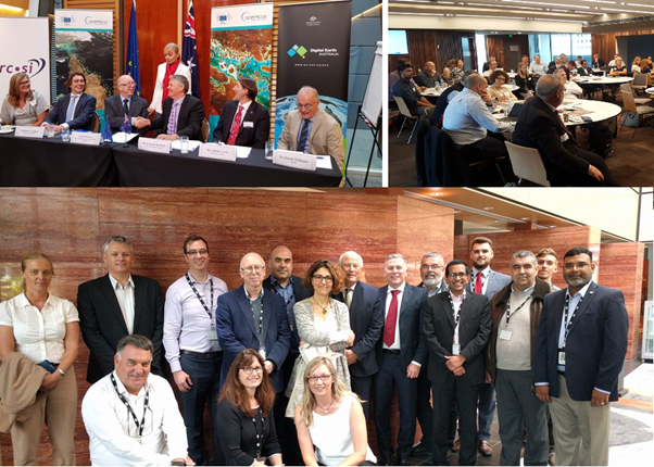
Already this year, we have signed two international agreements – with AGI in India and CRCSI in Australia. I reported on the first in my last editorial in January. The second was concluded during a trade mission to Australia we organised with CRCSI at the beginning of March. The mission was timed to coincide with the visit of Commissioner Elzbieta Bienkowska who is responsible for DG GROW and the Copernicus programme. The mission involved 7 European companies, and over 60 Australian companies attended the three workshops in Brisbane, Canberra and Sydney. In Canberra, I joined a panel discussion held in the presence of Commissioner Bienkowska regarding co-operation between Europe and Australia in the field of EO services including Copernicus. More information on the mission can be found here
INTERVIEW
INTERVIEW with Graeme Kernich – CEO of the CRCSI
About the Cooperative
Research Centre for Spatial Information (CRCSI)
CRCSI is an international research and development centre set up in 2003
under the Australian Government Business Cooperative Research Centres
Programme. CRCSIconducts user-driven research in spatial information that
addresses issues of national importance in Australia and New Zealand. There
partners include government agencies, universities and over 50 companies.
INDUSTRY PROFILE
3DEO deploy their disruptive RF link solution
By combining technologies from immersive 3D, financial services, television and earth observation, 3DEO have developed a new approach to the interaction with and presentation of diverse data, from space to smart phones. 3DEO think and inform visually revealing much more than can be seen from traditional perspectives. 3DEO solutions have widespread application, from defense to disaster risk management, estate management and financial markets insight.
EARSC ACTIVITIES
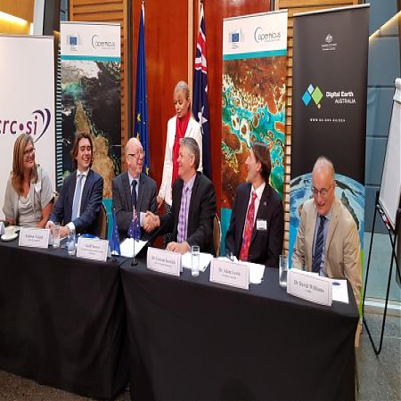
Brussels, 7th March 2018: The European Association of Remote Sensing Companies (EARSC) and the Cooperative Research Centre for Spatial Information (CRCSI) through Spatial Information Systems Research Ltd (SISR), signed a Memorandum of Understanding (MoU). Representatives from the EARSC member companies AIRBUS, e-geos, Earth-i, Geospatial Enabling Technologies, GMV, Planet, and Sinergise attended the ceremony.
EARSC organised a Trade Mission to Australia - 5th to 9th March 2018
EARSC is organising a Trade Mission to Australia, traveling with seven European companies.
EARSC participation at FIDAE 2018, Chile
EARSC participated to the Matchmaking Event at FIDAE 2018 – Business Beyond Borders
20 March 2018. EARSC publish today its position paper on Usage of Open Street Map versus National Data for CORINE Land Cover plus (CLC+) – “CLC Backbone.
Are you providing training
courses related to Earth observation (EO) / Geoinformatics (GI)?
Are you working in the EO and/or GI sector (in a private, public or academic
organization)?
You have 6 weeks to contribute with 5 minutes of your time to the development of an innovative strategy for skills development and capacity building in the Earth observation (EO) and Geoinformatics (GI) field, supporting Copernicus user uptake.
Farm Management Support in Denmark
The first of our next series of studies into the benefits driven by Sentinel satellites is published. This looks at a service provided by start-up Fieldsense in Denmark using Sentinel 2 data to offer precision farming products.
MEMBER NEWS
20 years of vegetation monitoring! What's next?
Today we travel back in time, to March 24th 1998. It is exactly 20 years ago that the first VEGETATION instrument was launched on board the SPOT 4 satellite.
20 years may go unnoticed in the evolution of the Earth, but leaves its footprint in the lifespan of a man. Not only because of the immense technological progress that was made, but even more for the growing importance remote sensing and geo-information play nowadays in our daily life.
Airborne Technologies breaks the ice
Airborne Technologies is proud to have obtained FIKI certification from EASA for the Vulcanair P68R.The aircraft type is thus approved for “Flights Into Known Icing” conditions.
Toulouse, 10 April 2018 – Airbus has entered into an agreement with Twenty First Century Aerospace Technology Co. Ltd (21AT), the Chinese commercial satellite operator, for the distribution of the images acquired by their TripleSat constellation.
Business opportunities from outer space
Sinergise: A Slovenian company is creating new business opportunities by optimizing data mined by the EU’s Copernicus programme from outer space.
cloudeo and geo university have teamed up to make you a geo-expert
gis and geography are becoming increasingly important not only in the geosector or in clearly geo-related business, but also in a variety of different fields. more and more companies in the maritime, logistics, insurance, risk management or agricultural sector are recognizing the potential of geodata and the insights derived from it.
Copernicus Data Warehouse Offers 40 cm Imagery Exclusively From European Space Imaging
The Copernicus Data Warehouse is now offering eligible users the ability to order 40 cm satellite imagery in remarkably quick time frames, thanks to a 24 hour service exclusively available from European Space Imaging and its partner DigitalGlobe.
Deimos Imaging awarded GSA Contract
Deimos Imaging and UrtheCast have been awarded a GSA Multiple Award Schedule (MAS) 070 contract by the U.S. General Services Administration (GSA), the procurement arm of the federal government.
This is the first time that a European company in Earth observation services has been awarded such a contract in the U.S., making Deimos Imaging’s full portfolio of products and services available to all U.S. government agencies.
e-GEOS wins COSMO-SkyMed contract in Australia
(7 February 2018) e-GEOS, a joint venture of Telespazio (80%) and the Italian Space Agency (20%), strengthens its international presence with an important agreement signed in Australia for the supply of data generated by the Italian COSMO-SkyMed satellites.
EARTH-i receives £2.7 million from UK Government to improve crop yield for African coffee farmers
EARTH-i, one of Europe’s most prominent New Space companies, has been awarded a grant of £2.7 million from the UK Space Agency’s International Partnership Programme, which supports UK space firms tackling global challenges.
Earth-i releases its first full-colour video of Earth taken from space
‘New Space’ pioneer Earth-i today released the first video taken by VividX2, the technology prototype for its Vivid-i constellation
First, validated Sentinel-2 based land cover map for Austria
GeoVille is delighted to announce the release of the first, validated Sentinel-2 based land cover map. It’s the first national implementation retrieved via landmonitoring.earth, a fully-automatic land monitoring solution set-up by GeoVille. The homogenous and seamless land cover map was produced for entire Austria covering an area of 84,000 km².
From traditional border control to tactical and strategic surveillance
Border Areas are at the centre of today’s geopolitical challenges and geopolitical developments. Terrorism, illegal immigration and trafficking, proximity to crisis zones, EEZmonitoring and the need for in-depth ISR are some of their current defining characteristics. Also, the multi-faceted threats generated within border geographic neighbourhood are ever-changing and blended. In the last five years, we have seen major crises in neighbouring regions, especially in the Middle East and Africa, that bring wider European implications and the likelihood of unpredictable developments, which necessitate an early warning and constant monitoring system.
GAF currently completed an ESA funded project to support the African Mineral Geoscience Initiative (AMGI). The World Bank initiated AMGI Project is a pan-African initiative for the collection, consolidation, interpretation and effective dissemination of national and regional geological, geochemical, geophysical and mineral resource data through a geo-portal. It intends to develop a complete Geological Data Catalogue for entire Africa in relation to mineral resources.
GAF continues to provide Ocean Colour Data to ESA operationally
ESA and GAF agreed the continuation of the data acquisition from the Ocean Colour Monitor (OCM) aboard the Oceansat-2 Indian remote sensing (IRS) satellite until 31‑Mar‑2019. Part of the agreement is also an option to extend the operations up to 31‑Mar‑2020.
Geospatial industry must adapt and adopt to technological changes – Richard Blain, Earth-i
Rapid growth in the types and diversity of sensors available to collect data — from ground sensors, to drones, to rapid advancements in satellite technology — and the application of machine learning and AI is set to radically change the way geospatial data is used.
Geospatial Insight and Deimos Space UK have been granted funding from the European Space Agency (ESA Business Applications) to further develop RetailWatch, with an initial focus on the European market. The project is part of the European Space Agency’s (ESA) business applications programme, which is dedicated to the development of applications and services using different space assets, including satellite imagery.
How EO data is used for humanitarian response
VITO Remote Sensing distributes processed Earth Observation data to users worldwide. In this blog, we are giving the word to Action Contre La Faim (ACF) describing their use of PROBA-V data for monitoring West-African cattle herders. Their work is an interesting example of how global Earth observation data can be used to support pastoralists locally.
Planetek awarded contract by eu satcen to support frontex border surveillance activities
Planetek Hellas and Planetek Italia have signed a framework contract with the European Union Satellite Center (SatCen), for the provision of Earth Observation based Very High Resolution Reference Mapping products in support to FRONTEX, the European Border and Coast Guard Agency.
Planetek italia and descartes labs announce partnership to analyze big satellite data in the cloud
Descartes Labs and Planetek Italia have announced a partnership to transform big data from space into actionable knowledge for global users. The agreement brings together Descartes Labs’ machine learning algorithms and computer vision tools with Planetek’s monitoring services based on the Rheticus® cloud platform.
Rezatec, the leading provider of geospatial data analytics to the Forestry sector, today announced that it is to provide its forestry attribute data products to the BC Oil and Gas Research and Innovation Society (BC OGRIS), the not-for-profit society enabling research to inform environmental matters related to oil and gas exploration and development in British Columbia.
Satellite Video- An invaluable tool for catastrophic destruction
Hurricane Irma was the largest Atlantic storm in the last decade. It was the 5th costliest hurricane on record in the U.S.A, causing $5 billion of damage after hitting the south west coast of Florida and moving up through Atlanta and Georgia. A 3m storm surge in the Florida Keys caused damage to approximately 90% of all buildings and collapsed 25%. Disaster response teams struggled for weeks to clear debris and distribute aid. A key requirement for dealing with the destruction was access to timely, accurate information about ground conditions after the storm.
Space Dynamics and control: the embedded model control approach
The book ‘Spacecraft Dynamics and Control: The Embedded Model Control Approach’ provides a uniform and hands-on approach to space engineering control problems. Published in March 2018, it introduces the Embedded Model Control methodology for the design and implementation of attitude and orbit control systems.
Spatiospectral processing, the key to high resolution hyperspectral imaging
Precision agriculture aims to optimize returns by automated observation of crop fields using small unmanned aerial vehicles. The challenge is to provide a complete system that combines very high spatial resolution and detailed spectral measurements to extract the information you need.
Let me tell you how a compact camera, like ButterflEYE LS, combined with our new spatiospectral processing chain allows you to image agricultural fields to analyse vegetation down to the individual plant level, while detailed spectral measurements allow early detection of vegetation stress and diseases.
The Netherlands Builds support structure for the world's largest telescope
VDL ETG Projects, part of VDL Groep, will build the support structure for the main mirror of the Extremely Large Telescope (ELT) of ESO (European Southern Observatory) in northern Chile. The design was realised together with TNO, supported by NOVA (Netherlands Research School for Astronomy). The support structure consists of 798 supports for mirror segments, which together form the main mirror (with a diameter of more than 39 meters) of the telescope. This order, which will be delivered over a period of about five years, is worth tens of millions of euros. This represents a special achievement by Dutch industry.
The Pentagon Is Asking for Satellite Imagery Algorithms
ON A TRIP to Silicon Valley last year, Defense Secretary James Mattis openly envied tech companies’ superior use of artificial intelligence technology. To help close the gap, one Pentagon unit is now offering $100,000 in prizes to develop algorithms that can interpret high-resolution satellite images.
Unlocking Insights from Video Data
Watch the latest Earth-i video blog as members of our technology team discuss how we’re delivering brand new types of data that provide full motion 4D context to space-derived Earth Observation intelligence. With detailed analytics and insights capabilities, innovators, policy makers, and geospatial professionals can make more effective decisions, more rapidly.
EARTH OBSERVATION NEWS
AI and Satellite Imagery to Power a New Revolution in Agribusiness
Agronow is spearheading a new revolution it calls Agriculture 5.0, through which it aims to monitor crops by using Artificial Intelligence (AI), making it possible for all sectors involved in agribusiness — banks, tradings, lenders and insurers — to receive alerts, information, analyses and projections that are fundamental for remotely strategic decision making.
Aker Arctic and ICEYE team to improve ice navigation safety
Finnish companies Aker Arctic Technology, the world leader in ice-going vessel design and engineering, and ICEYE, the leader in synthetic-aperture radar (SAR) technology for microsatellites, joined forces to develop and provide satellite ice information and related services for customers operating in icy conditions.
Army Geospatial Center Extends Contract with Radiant Solutions
Radiant Solutions has signed a follow-on contract with the Army Geospatial Center (AGC) valued at $2.6 million for its Remote Ground Terminal (RGT) program. AGC exercised an option extending Radiant Solutions’ provision of systems engineering and software development to enhance the RGT program, which mission is to provide timely access to high resolution commercial imagery for the military and humanitarian aid/disaster relief.
Australian Vineyard Health Monitored by Satellite Imagery and AI Software
An Australian-first agricultural artificial intelligence software has combined machine learning and high-resolution satellite imagery to provide wine industry insights into vine health — Geospatial Artificial Intelligence for Agriculture (GAIA) has been developed by Adelaide-based company Consilium Technology, in partnership with DigitalGlobe and Wine Australia.
BlackSky, the geospatial intelligence service of Spaceflight Industries, today announced the first of its next generation of small Earth observation satellites is complete, qualified, and awaiting launch. This spacecraft, called Global-1, is the first of four smallsats that are scheduled to launch in in the next year on both US and foreign launch vehicles.
Could Africa’s agricultural challenges be solved by satellite data?
There has been a significant growth in the availability of satellite data in recent years, providing access to information on air quality, soil composition, ocean currents, and seismic activity.
Delivering Earth observations worldwide: GEONETCast
Earth observations contribute to increased understanding of complex phenomena occurring in, on and around our planet. Such observations allow the international community to make more informed decisions and policies to address global challenges, such as climate change and disaster resilience.
Demystifying Global Oil Stocks Using Geospatial Intelligence
For many years, a dearth of reliable information regarding global oil inventories meant that oil traders and market analysts lacked the full picture when making trading decisions. In response, Geospatial Insight developed TankWatch to provide the market with precise, near real-time insight into above ground oil storage for any location worldwide, enabling better price risk management options and enhanced decision-making capabilities.
EOMAP has been awarded a contract for providing Satellite Derived Bathymetry for seven atolls of Tuvalu — the project was awarded through a competitive bid contract issued and overseen by the UK Hydrographic Office (UKHO).
EOS Offers Remote Sensing Data for Agriculture
Earth Observing System (EOS), a Menlo Park based startup, has released a unique cloud-based platform called EOS Crop Monitoring, which provides solutions for farmers and all sectors of the agriculture supply-chain.
ESA Investigating detection of floating plastic litter from orbit
The millions of tonnes of plastic ending up in the oceans every year are a global challenge. ESA is responding by looking at the detection of marine plastic litter from space, potentially charting its highest concentrations and understanding the gigantic scale of the problem.
First ever national maps of Australia’s ecosystem
Mapping a continent’s ecosystem is a complex business — and one for which disparate methodologies have been employed across Australian jurisdictions — until now.
Marking the International Day of Forests, this Copernicus Sentinel-2 false-color image shows an area of Bolivia that was once covered by trees but has now been cleared for resettlement and agriculture.
GISCafe Special Coverage: The World of State-of-the-Art Satellites, Reusable Spacecraft and More
Both large full size satellites as well as small satellites are now being used for various purposes around the globe. In addition, constellations of satellites are being developed for specific purposes, such as internet satellites. We also include here maritime surveillance that relies on Satellite Automatic Identification System (AIS) payload.
How NASA Satellites Are Helping to Halt Malaria Outbreaks
NASA’s Earth-observing satellites can track the forces that create malaria outbreaks, and their data will soon help local communities make big strides toward warding off the deadly disease.
Hyperscout succesfully captures first images from space
HyperScout, the first miniaturized hyperspectral camera in space, has captured its first images. Developed by an international consortium led by cosine, HyperScout was launched into space on 2 February 2018. The images are the first Earth observation images of their kind captured by an instrument onboard a nanosatellite.
ICEYE and European Space Agency Announce Partnership to Change the Future of Earth Observation
New Space movement in Europe ramps up with the aim of improving access to crucial satellite imaging data
INNOspace Masters “Space Moves!”
Competition set to culminate in conference and awards ceremony on 05 June 2018 in Berlin
Leading a new Earth Observation project to help predict dengue fever outbreaks
The prevalence of dengue fever poses a global health issue, with half the world’s population now estimated to be at risk from this mosquito-borne viral infection (WHODengue Factsheet, April 2017). Found in tropical and sub-tropical climates worldwide, mostly in urban and semi-urban areas, the infection causes a flu-like illness which can develop into a potentially lethal complication known as severe dengue. HR Wallingford is leading a new project utilising Earth Observation technology, and funded by the UK Space Agency’s International Partnership Programme, to develop an early warning system which will help to predict dengue fever outbreaks in Vietnam.
Mapping migrant flows with satellites
How can asylum and migration flows into Europe be detected earlier? This was the central question in a successful feasibility study conducted recently by Statistics Netherlands (CBS) and IT company CGI, using data collected from earth observation satellites and social media. The study was commissioned by the European Space Agency, ESA. Project leader for CBS Bob van den Berg and CGI business consultant Bernd Burger provide details of this innovative experiment.
Meet the Satellites That Can Pinpoint Methane and Carbon Dioxide Leaks
The world’s first space-based system to help identify specific sources of greenhouse gas emissions is now circling the Earth.
New land motion map shows the human impact on the UK landscape
Researchers at the University of Nottingham who developed groundbreaking technology which was used to create the first country-wide land motion map of Scotland, have scored another first by creating a new UK-wide ground motion map.
New online remote sensing application for land cover classification and monitoring with Landsat data
REMAP app is an open-access online application for land cover classification and monitoring. The application is aiming to extend the ability of volunteers, managers, and scientists to assess the extent of land cover changes and implement actions to help the conservation of natural environments around the world under the IUCN Red list of ecosystems.
New tool combines lightning and satellite data to improve forecasts of tropical cyclones
A group coordinated by the University of Washington in Seattle has developed a tool to facilitate continuous monitoring of tropical cyclones through the combination of lightning and microwave satellite data. The World Wide Lightning Location Network’s (WWLLN) tropical cyclone (WWLLN-TC) platform is publicly accessible and visualizations of the global data are updated every three hours.
Observing the Earth, Fueling Global Development Solutions
Radiant.Earth’s mission is to make Earth observation (EO) imagery and data easier to discover, analyze and apply for unique insights to the issues the global development community encounters daily. The science of remote sensing and the Earth observation marketplace is evolving rapidly given the innovations of cloud computing, machine learning, drone technology and the NewSpace movement. Even for the most knowledgeable and informed experts, it is difficult to keep up with this wave of innovation. This is especially true for professionals dedicated to delivering solutions in the field.
Open Geospatial Consortium announces the European Space Agency’s upgrade to Strategic Membership
The Open Geospatial Consortium (OGC) is pleased to announce that the European Space Agency (ESA) has raised its membership level from Technical to Strategic – OGC’s highest level of membership.
PlanetObserver Announces Release of PlanetSAT Global Imagery Basemap Version #2018
With an unmatched 10-meter resolution at the global scale, PlanetSAT Global #2018 mosaic provides accurate geographic information for any part of the world. Users benefit from a seamless view of the Earth in high quality natural colors, for an enhanced visual experience!
PlanetObserver Releases PlanetSAT Global Imagery Basemap Version #2018
PlanetObserver has released the most up-to-date global mosaic processed with recent and cloud-free satellite imagery.
Protected Area from Space: a website
A new ECOPOTENTIAL service has been released! The section “Protected Areas from Space” has been added to the ECOPOTENTIAL website. It consists of a web map server showing and delivering all satellite data and metadata produced within the project. Data can be displayed, analysed and directly downloaded in several GIS formats.
Radiant Solutions to Accelerate Machine Learning Tech for NGA
Radiant Solutions announced a contract with the U.S. National Geospatial-Intelligence Agency (NGA) to provide more than 1 million labeled objects within high-resolution satellite images that will be used to accelerate the development of machine learning algorithms that can extract valuable information from imagery at scale.
Regional Data Cube to Help Manage Food Security in Africa
The African Regional Data Cube has been launched at the Global Partnership for Sustainable Development Data’s inaugural Data for Development Festival in the United Kingdom. This new tool harnesses the latest Earth observation and satellite technology to help Kenya, Senegal, Sierra Leone, Ghana, and Tanzania address food security as well as issues relating to agriculture, deforestation, and water access. The Committee on Earth Observation Satellite (CEOS) in partnership with the Group on Earth Observations, Amazon Web Services, and Strathmore University in Kenya developed the data cube.
Satellites Predict a Cholera Outbreak Weeks in Advance
A test in Yemen showed satellite data could foresee an outbreak four weeks before it exploded
Scepter Inc. unveils plan for global atmospheric monitoring constellation
Scepter Inc., a Silicon Valley startup, unveiled plans March 22 to launch a constellation of satellites to provide global atmospheric monitoring services for government and commercial customers.
South African satellite creates business for local industry
A South African manufactured nanosatellite orbiting Earth since May last year is doing so well that it has generated sales of some of its sub-systems on the international satellite market.
SpaceDataHighway starts full Copernicus service
The Airbus-operated SpaceDataHighway has begun regularly relaying data from the Sentinel-2A satellite, after the successful end of the commissioning period. This marks the start of the SpaceDataHighway service using all four Copernicus Sentinel satellites and the beginning of a new era for space-based imagery users.
Spaceflight raises $150 million for BlackSky constellation
Spaceflight Industries announced March 13 that it has raised $150 million to fund development of the next phase of its BlackSky Earth imaging constellation, with Thales Alenia Space and Telespazio taking minority stakes.
Supporting food security from space
For a food secure world, agriculture needs to get digital, i.e. we need “smart” agriculture to ensure food for all. Combining and analyzing this “Big Data” sets to monitor agriculture is key for a sustainable future.
The Copernicus Programme is a cornerstone of the EU’s effort to monitor the Earth and provides tremendous amount of data available on a full free and open basis. This amount of data is causing a paradigm shift in the remote sensing community. No longer is the data being brought to the user but the user and his/her knowledge is brought to the data. It is our goal to develop innovative and user-friendly platforms as an answer to this Big Data Challenge we are all facing. ESA’s Thematic Exploitation Platform on Food Security (TEP-FS) is a potential solution.
With the aim of making the best possible use of existing satellites, ESA and Canada have made a deal that turns Swarm into a four-satellite mission to shed even more light on space weather and features such as the aurora borealis.
Track the Vital Signs of the Ocean with the Ocean Monitoring Indicators
The Copernicus Marine Service is pleased to announce the launch of a new ocean information product, the Ocean Monitoring Indicators (OMIs). OMIs are free downloadable data sets covering the past 25 years of the key variables used to monitor the oceanic trends in line with climate change, including ocean warming, sea level rise and melting of sea ice. This free and open ocean information allows users to track the vital health signs of the ocean over the past quarter of a century.
UK team delivers Earth observation instrument that will improve climate knowledge
A broadband radiometer instrument, designed and built in the UK with the aim of improving our understanding of the Earth’s climate, has been delivered to the EarthCARE mission team in Germany.
Very small satellites, very big deal
A flock of Doves takes detailed pictures of the whole Earth every day. You’ve probably seen their photos, or read a headline informed by the data they gather. What can the Army learn from these birds and the former NASA engineers who set them aloft?
“SPACED: Using Earth Observations to Protect Natural Landscapes” exhibition in Bruxelles
ECOPOTENTIAL has landed at the European Parliament in Brussels! From 8 to 12 January 2018, the Place du Luxembourg building hosted the exhibition “SPACED: Using Earth Observations to Protect Natural Landscapes”.
PROGRAMMES
The Copernicus programme launched in 1998 under the name GMES (Global Monitoring for Environment and Security) is the European flagship Earth observation programme, created with the objective of collecting Earth observation data to support, mainly, policy making.
Big Earth Datacube Analytics Made Easy
The BigDataCube project is developing flexible and scalable services for massive spatio-temporal Earth Observation (EO) data, offered as datacubes. This paradigm replaces the millions of EO files by a few massive multi-dimensional space/time objects, such as 3D image timeseries and 4D weather forecast cubes. This way, raster data get ready for spatio-temporal analysis in the large.
Copernicus for Cultural Heritage: satellites to preserve the legacy from our past!
2018 is the European Year of Cultural Heritage. Throughout the year, tangible and intangible, as well as natural and digital cultural heritage of Europe is celebrated. The free and open data and information delivered by the Copernicus programme represents a valuable resource for Cultural Heritage monitoring and preservation at European and global level.
Copernicus Masters: An Important Innovation Driver for Earth Observation
Copernicus is Europe’s most ambitious Earth observation (EO) programme and provides full free and open access to data for the development of applications in a wide variety of domains. The Copernicus Masters awards recognise applications and ideas that are using Copernicus data to tackle important challenges faced by business and society. From 1 April to 30 June, Copernicus Masters participants can submit their innovative EO ideas for solving any of the 16 challenges offered by the largest number of world-class partners since the competition started.
DigitalGlobe to Map Buildings Using Machine Learning in the Cloud
DigitalGlobe has formed a partnership with Ecopia Tech to use proprietary Artificial Intelligence (AI) algorithms and cloud computing to create building footprints. By using Ecopia’s U.S. Building Footprints powered by DigitalGlobe, customers will have current information on structures in their areas of interest.
EO data for agricultural insurance
Tonight at dinner you might not think about poverty, hunger, and poor nutrition, but unfortunately that’s not the case for one in nine people in the world. About 815 million people are going to bed hungry. It makes sense that one of the greatest challenges we are facing today is how to ensure global Food Security and achieve Zero Hunger, one of the UN’s Sustainable Developments Goals (SDG 2).
Investing in smallholders is key to address food security, among them are many of the rural poor, vulnerable to risks. In the project “Improving Agricultural Risk Management in Sub-Saharan Africa: Remote Sensing for Index Insurance” we investigated ways to improve agricultural insurance for smallholder farmers by using remote sensing.
ESA testing detection of floating plastic litter from orbit
The millions of tonnes of plastic ending up in the oceans every year are a global challenge. ESA is responding by looking at the detection of marine plastic litter from space, potentially charting its highest concentrations and understanding the gigantic scale of the problem.
India: To allow the benefits of the European Union’s Copernicus Earth Observation and Monitoring programme and of the Indian fleet of remote sensing satellites to extend beyond the borders of the partners, in Bangalore, on 19 March, the European Commission and India’s Department of Space signed a landmark Cooperation Arrangement related to sharing of Earth observation satellite data.
Europe’s environment: the power of data and knowledge
Europe collects increasingly more data, enhancing our understanding of the environment. Earth observation data obtained through the European Union’s Copernicus programme presents new challenges and opportunities to improve our environmental knowledge. Combining up-to-date Copernicus data with our existing knowledge base, the European Environment Agency (EEA) aims to empower policy makers and citizens across Europe in taking measures to address local, national and global challenges.
The complete set of Copernicus services for Security applications became fully operational in May of 2017, marking a historic milestone for the Copernicus programme. Following the signature of Delegation Agreements between the Entrusted Entities and the European Commission, industrial contracts for the provision of services were granted.
Ground-breaking satellite projects will transform society
A scheme to use satellites to support the roll out of charging points for Electric Vehicles is one of eight new projects announced by the Science Minister Sam Gyimah today.
JAXA/ESA joint statement concerning bilateral cooperation
On 03 March 2018, on the occasion of the International Space Exploration Forum (ISEF2), the Japan Aerospace Exploration Agency (JAXA) and the European Space Agency (ESA) held an Inter-Agency Meeting to discuss furthering their bilateral cooperation.
Researchers create tool to better geographic projections in atmospheric modeling
Open-source code developed by a Penn State graduate could improve weather forecasting and a range of other research endeavors that rely on pairing atmospheric models with satellite imagery.
The Copernicus Masters 2018 launched
Copernicus is Europe’s most ambitious Earth observation programme and provides full free and open access to data for the development of applications in a wide variety of domains. It is estimated that investments in the programme will increase to EUR 7.5 billion by 2020, while the economic benefit is expected to double in value. Every euro invested in Copernicus activities by public authorities, results in a EUR 1.4 benefit to the whole economy. The Copernicus Masters awards applications and ideas that are using Copernicus data to tackle important challenges faced by business and society, with 2018 submissions opening 1 April
Three Gaofen Earth observation satellites launched by China
China has launched its 10th space mission of the year, deploying three civilian-operated Earth observation satellites with cameras to help monitor natural disasters, survey natural resources and assist in infrastructure planning.
UK satellites to help monitor ASEAN forest fires
The UK Space Agency will use satellite imagery and earth observation data to help countries in Asia tackle forest fires, dengue and illegal fishing, it was announced.
UNESCO launches a pioneering tool to monitor water quality
A new World Water Quality Portal (link is external), launched by UNESCO’s International Hydrological Programme (IHP), provides information on freshwater quality at the global scale using remote sensing data. Water quality affects human health, as well as ecosystems, biodiversity, food production and economic growth. While improving water quality worldwide is essential to sustainable development, reliable data is scarce, especially in remote areas and developing countries where monitoring networks and capacity are lacking.
UNESCO Tool Monitors Water Quality
UNESCO developed a tool to monitor water quality using Earth Observation.
The International Initiative on Water Quality (IIWQ) World Water Quality Portal fosters understanding of the impacts of climate- and human-induced change on water security.
EVENTS