Skip to content

The first-ever European Carbon Farming Summit hosted by the EU-funded CREDIBLE project (www.credible-project.eu) convened in Valencia (Spain) in March 2024 a vibrant community of over 600 professionals, organisations and enthusiasts dedicated to carbon farming and soil management. The event highlighted the community’s strong commitment and enthusiasm for recognising the potential of carbon farming.  Carbon farming presents exciting opportunities, with long-term benefits being uncovered through collaboration and innovative techniques, as well as challenges for successful implementation. EARSC actively led the discussion about the role of Earth Observation on Carbon farming and follow this exchange with experts on a monthly basis. If you would like to engage, please reach out to info@earsc.org
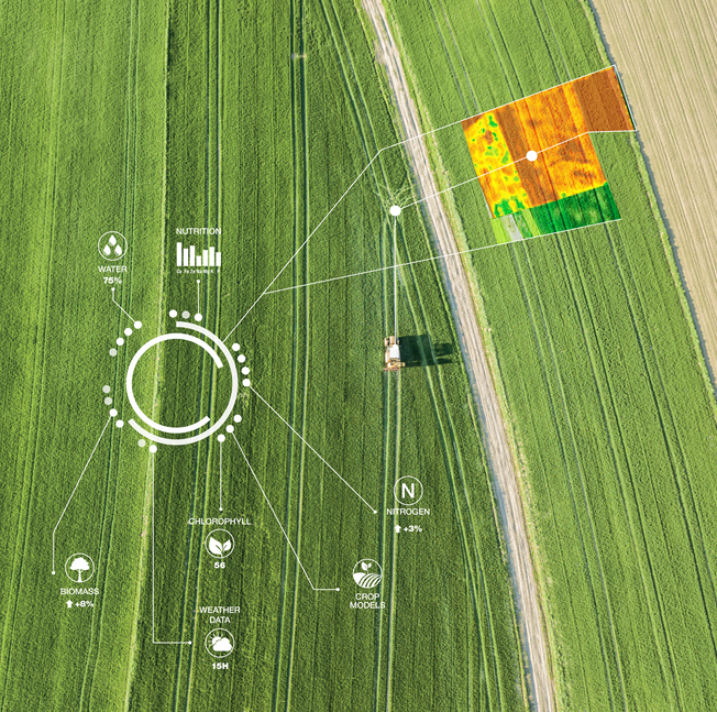
EO4CarbonFarming

The event provided some key insights: i) The EU Carbon Removal Certification Framework is a crucial component of Europe’s strategy to achieve net-zero emissions by 2050. The objective of this framework is to set the standards and guidelines for certifying and verifying these carbon removal methods, ensuring they meet the required environmental and technical criteria. ii) Measuring and monitoring are crucial for assessing the impact of any mitigation action, and carbon farming follows the same logic: climate claims linked to shifting agricultural management must be proven and validated. This is needed to offer clear quantification guidelines covering both soil emission reduction units and sequestration units, while at the same time acknowledging the impermanent nature of biogenic carbon. Proper and continuous monitoring ensures that the claimed carbon removals are genuine and verifiable. This not only serves as a technical requirement but is also fundamental in establishing trust and credibility in the carbon credit market among investors, policymakers, and the public. iii) The necessity of a harmonised approach to carbon credit certification across Europe. The current fragmented methods of certification create inconsistencies and uncertainties in the carbon credit market. iv) Farmers are central to the success of carbon farming initiatives. Their knowledge, skills, and on-ground experience are invaluable for implementing effective carbon sequestration and emission reduction practices. Complementary financing mechanisms and incentives need to be explored and farmers should be empowered through education, training, peer-to peer learning and ongoing support is crucial to accelerate the adoption and scaling of carbon farming practices across Europe. v) Carbon farming is a diverse and context-specific solution. Localised strategies and landscape-level initiatives, involving collaboration with local stakeholders such as communities, landowners, and agricultural organisations, are vital. These initiatives foster trust, enable better adaptation to diverse farming landscapes, and ensure that carbon farming practices are both effective and sustainable.

By embracing a multi-actor approach, encouraging collaboration among stakeholders, and implementing progressive and responsible policies, Europe can fully unlock the potential of carbon farming, positioning it as a cornerstone of its sustainability strategy. As we transition from theory to action, one thing is clear: the future of carbon farming in Europe is promising, but it demands concerted effort, innovation, and collaboration to realise its full potential. Would you like to join the conversation? Sign up to be informed about the next Carbon Farming Summit in Ireland in March 2025 (sign up).

The Canal Seine Nord Europe stands as a monumental testament to modern engineering, arguably the most significant civil engineering project in Europe this century. With its vast scale, the project encompasses a decade of work, stretches over 100 kilometers, and involves the excavation of more than 70 million cubic meters of soil. Yet its ambitions go beyond mere construction; it aims to transform goods transportation in Europe, promising to divert approximately 5 million trucks from the roads annually, significantly reducing carbon emissions and traffic congestion.

This initiative aligns with contemporary environmental goals, marking a bold step forward in an era committed to curbing global warming and protecting biodiversity. By bridging the fluvial networks of Northern Europe with the Seine Maritime, it paves the way for more sustainable goods transportation across the continent.

The project has garnered support from the French Region Haut de France, French government, and the European Union, all demanding regular updates on progress and environmental impact. However, the project’s sheer scale challenges traditional monitoring methods, such as drones, which fall short in providing the needed comprehensive data.

Disaitek approached in mid-2022 to pioneer a satellite-derived data solution. After a year of rigorous discussion and negotiation, Disaitek was entrusted with an experimental contract to oversee the project’s progress and its environmental footprint. Our commitment spans three critical areas:

  • Work Progress Monitoring: We ensure meticulous measurement and traceability for excavated soils and oversee the construction progress of roads and fluvial locks and ancillary works.
  • Environmental Impact Assessment: Our high-precision mapping technology tracks vegetation and supports a nature-based compensation program, alongside automated crop identification.
  • Encroachment Detection: We vigilantly monitor operational boundary exceedances, illegal land use, and road deterioration.

We task the Pléaides satellite on a monthly basis, both mono and stéréo depending on location and use cases, to provide detailed imagery to feed our algorithms and AI models, achieving remarkable success in our objectives. Our GIS-based platform offers stakeholders easy access to a wealth of analyses across these domains.

As our experimental phase nears completion, we stand on the brink of negotiations to establish our platform as the project’s monitoring tool during its construction and exploitation phases.

The Large -scale Skills Partnership (LSP) for Space Data, Services and Applications (SPACE4GEO), promoted under the European Commission’s (EC) initiative Pact for Skills, aims to empower workers with the skills needed for the development of future innovations and to achieve the aims of the EU’s Space strategies. 

In line with the principles governing the Pact for Skills and its Charter, the proposed LSP wishes to ensure continuous exchange and cooperation among stakeholders from the academic, private and public sectors on skills development and requirements.

To this purpose, the partners are committing to establish and deliver a shared understanding of the volume of skills needs and capacity requirements needed (in the short, medium and long term) to achieve the high level vision of a successful space downstream and geoinformation sector.

The vision is being translated into strategic commitments which will lead to a certain impact that contributes to bridging the skills gaps and mismatches and an improved user uptake of space data, services and applications. 

Specific commitments for the Partnership are:

  • To monitor the occupational supply and demand to identify the skills and competences required and provide feedback on the evolving sector needs.
  • To help and guide candidate learners in their skilling, upskilling and reskilling efforts, supporting them to access quality training, promoting upskilling and reskilling of 3.5% of the workforce each year by 2030 across the ecosystem.
  • To facilitate and stimulate a more integrated and inclusive approach on skills development across different value chains (vertical sectors) and at different levels, including local and regional level.
  • To encourage citizens’ engagement, citizens’ science practices and hands-on activities enhancing the inclusion/recognition of space downstream and geoinformation applications’ value in everyday aspects of life, also attracting new talents to the present and emerging space geospatial professions.

To this purpose, EARSC as the partner of SPACE4GEO has committed to contribute to the establishment and delivery of a shared understanding of the volume of skills needs and capacity requirements needed (in the short, medium and long term) to achieve the high-level vision of a successful space downstream and geoinformation sector, as the latter faces a number of challenges, including a gender imbalanced workforce, an aging society and a shortage of relevant skills.

Source:

SpaceSUITE is an Erasmus+ Blueprint project for the development of innovative resources for education and training to bridge the gap between the supply and demand of skills in the ever-growing downstream space sector. The project was kicked off in January 2024, and it will end in December 2027. It integrates 28 partners, including 3 affiliated entities, from Academia, vocational education and training (VET) providers, associations, and representatives of industry companies. The partnership is complemented by 9 associated partners, mainly local and regional public bodies. The project was promoted in the framework of the SPACE4GEO Large-scale Skills Partnership on Space Data, Services and Applications (www.space4geo.euwere EARSC is key partner and will support the achievement of its strategic objectives in the framework of the EC initiative Pact for Skills.

With the aim of ensuring the development of advanced skills in space-related fields and the provision of education and training activities for higher education and VET providers for upskilling and reskilling, in particular for professionals, entrepreneurs, graduates and students, the SpaceSUITE consortium will:

  • release a Sector Skills Strategy, providing details on the way major trends in the downstream space sector are expected to impact skills’ needs in the sector, which will be continuously updated, and defining the roadmap to ensure medium and long term skills development through up-skilling and re-skilling actions for the current workforce, as well as the attraction of talents from other sectors and among youngsters. 
  • enhance and further develop the Body of Knowledge (BoK) on Earth Observation and Geo-information, also embracing Positioning Navigation and Timing (PNT) and Satellite Communication (SatCom), 
  • design “core” curricula for current in-demand and emerging occupational profiles, develop educational and training materials, and organise training actions for different persona, from a technician to a decision maker,
  • create an online “Open Space Academia” to provide these contents in a open flexible manner using the most recent learning techniques and including guidance to candidate learners.

The direct beneficiaries of this action are the 230.000 professionals currently employed by the EU downstream  space sector, which accounts for close to 80% of the global space economy.

Sources:

SDGs-EYES is a three – year Horizon Europe Research and innovation action (RIA) project (January 2023 – January 2026) that aims to strengthen Europe’s capacity to monitor the the Sustainable Development Goals (SDGs) on the basis of Copernicus by building a portfolio of decision-making tools to monitor SDG indicators related to the environment from a cross-sectoral perspective and in line with the priorities and challenges of the EU Green Deal. 

Led by a consortium of 10 partners representing diverse disciplines, SDGs-EYES embodies the spirit of collaboration, cross-fertilization, and knowledge integration. One of the key strengths of SDGs-EYES lies in its ability to combine data from Copernicus’s six core services to develop more accurate SDG indicators. Through a scientific and technological framework, EARSC is leading the using engagement of the project facilitating access to Earth Observation (EO) information while enhancing its usability for a wide range of stakeholders, as e.g. national statistical offices, SDG custodian agencies such as FAO, UNEP, the Inter-Agency and Expert Group on Sustainable Development Goal Indicators (IAEG-SDGs) or the Working Group on Geospatial Information (WGGI), etc.

In addition to its core objectives, SDGs-EYES embarks on a pilot-driven approach. Indeed, the project solutions are demonstrated through four EU and one non EU pilot areas (Sahel Countries, North Sea area, City of Turin (Italy), Romania, and Cosenza province (Italy). 

Overall, SDGs-EYES aims to:

  1. Facilitate Access and Increase Usability of EO Information: SDGs-EYES focuses on designing and developing a robust framework for aggregating and processing EO data provided by Copernicus’s core services and the space and in-situ components. By improving the accessibility and usability of EO information, the project empowers stakeholders with valuable insights for decision-making.
  2. Improve Reliability, Robustness, and Accuracy of SDG Indicators: Through a pilot-driven approach, SDGs-EYES demonstrates the potential of Copernicus-enhanced measurement for six SDG indicators related to SDG13 Climate Action, SDG14 Life Below Water, SDG15 Life on Land, and a cross-goal indicator will be also formulated to explore the exposure of vulnerable communities under cumulative climate extreme. These indicators are evidence of the project’s commitment to advancing the quality and accuracy of SDG monitoring efforts.
  3. Advance Stakeholder Capacity in SDG Monitoring: SDGs-EYES seeks to empower stakeholders by creating a range of user-friendly data products tailored to simplify the tracking and reporting of specific SDGs. These service-oriented products are developed, showcased, and co-designed in collaboration with a diverse community of users and stakeholders within designated pilot areas.

More information about the project are available on the website: https://sdgs-eyes.eu/ and on the project social media channels: LinkedIn (https://www.linkedin.com/company/sdgs-eyes/)  and X (@SDGsEYES)

The HyperScout® product, by Dutch company cosine, is a line of miniaturized hyperspectral imaging instruments models produced in series and equipped with onboard analytics capability. They are designed to fit satellites the size of a shoebox, capturing images of Earth in a multitude of colors beyond the human eye’s perception. HyperScout enables real-time monitoring of various natural disasters such as floods, forest fires, desertification, ice detection, crop health, and more. Its capabilities have the potential to significantly enhance society’s decision-making processes regarding climate policy. In 2024, a HyperScout product will be deployed in space as part of two high-profile operational missions, focused on addressing climate change, environmental monitoring and leveraging the power of artificial intelligence: Thales-Microsoft’s IMAGIN-e and South Australia’s Kanyini

Climate change is increasingly significant across various agendas, gaining not only traction among technical and scientific communities but also political relevance. This shared urgency underscores the need for collective action toward sustainability, directly impacting our workforce and motivation. 

It is integral to cosine’s core mission and values to furnish the world with instruments capable of providing space-collected data to facilitate informed decision-making in areas such as climate policy, water usage, and disaster management. HyperScout is specifically designed to address environmental challenges such as climate change and its impacts, offering hyperspectral imaging in the visible and near infrared spectra to analyze Earth’s composition. Additionally, its three thermal infrared bands enable temperature distribution retrieval, expanding the scope of Earth Observation applications. With its onboard AI and analytics, HyperScout delivers processed information and coordinates in quasi-real time, facilitating rapid response to dynamic environmental changes.

Applications include: 

  • vegetation monitoring  
  • fire hazard monitoring  
  • volcano and fire monitoring  
  • soil moisture monitoring  
  • flooding delineation  
  • oil spill detection  
  • change detection  
  • water quality monitoring  
  • cloud detection  
  • urban heat island  

HyperScout for IMAGIN-e 

In March 2024, Microsoft, in collaboration with Thales Alenia Space, launched a satellite to the International Space Station to gather unmatched Earth observation insights. The IMAGIN-e (ISS Mounted Accessible Global Imaging Nod-e) payload aims to demonstrate and validate on-orbit computing technologies for multiple remote-sensing applications to address crucial challenges facing our planet’s sustainability. As a partner in this mission, cosine delivered a HyperScout M, the most compact version of hyperspectral imager among the product line. The image processing capabilities embedded in our hyperspectral imager, combined with its onboard computing hardware and an on orbit application framework, will enable unprecedented data processing for climate change applications. The app-like upload environment, which allows the deployment of new algorithms and runs them in orbit, will help address the challenging mission constraints. 

HyperScout for Kanyini 

Later in 2024, a HyperScout 2 will be launched as part of Australia’s top-level satellite mission Kanyini to observe the Earth. Data collected from the project is intended to support informed decision making in the areas of water usage, climate policy and disaster management. The spectral range offered by HyperScout enables an extremely detailed analysis of land cover, supporting research into crop health, forests, inland water, and coasts. Additionally, the thermal infrared imager will provide vital information on heat generators in South Australia.  

HyperScout in Production 

These are just two examples of the current use of HyperScouts in the fight against climate change. cosine organizes the production chain of its hyperspectral imagers directly at its headquarters in Sassenheim, The Netherlands. The models are produced regularly, with the possibility of adding specific software features discussed with clients. 

Explore more about HyperScout on cosine’ s website, and to purchase units from our available stock, please contact us via email at sales@cosine.nl. 

About cosine 

cosine is a leading worldwide company in the development of space instrumentation, such as Silicon Pore Optics for astronomy and remote sensing solutions with onboard analytics. We combine physics and technology to bring out-of-the-box solutions to our clients. We have been developing and delivering innovative measurement systems for space and industrial applications since 1998. Our company operates 1,300 m2 of cleanrooms and high-tech assembly facilities to build and test the systems we produce for customers at our headquarters in Sassenheim, The Netherlands.

Combining cutting-edge technologies and innovative agronomic practices is crucial in making agriculture more sustainable and resilient against climate change. Farmstar has been a leading solution in the French market for over 25 years and stands out as a flagship example of this evolution. Now, it is introducing the CHN method to its service, a new way to help farmers use nitrogen fertilizers smarter. This enhanced service will enable farmers to better manage their crops and contribute to the fight against climate change.

The CHN Method 

At the core of Farmstar now lies the CHN method, a revolutionary approach to nitrogen fertilization advisory developed by Arvalis – Institut du végétal. The CHN method functions like a smart tool, continuously assessing the needs of plants for its growth. It works interactively, integrating the nitrogen inputs provided by the farmers to determine the nitrogen requirements for their crops more accurately and efficiently. Trial results conducted in 2023 

show that implementing the CHN method has led to an average reduction of 12 kg/ha (Arvalis source) in applied nitrogen doses while maintaining optimal agronomic yields. This not only reduces production costs for farmers but also contributes to more sustainable resource use by limiting water pollution risks and preserving soil quality in the long term.

What Farmstar does:

Farmstar uses high-resolution satellite data and advanced agronomic models to provide farmers with accurate information on crop growth, plant health and input requirements, enabling them to make informed decisions throughout the crop cycle. From crop planning to yield management, Farmstar provides powerful fertilization advice to optimize agricultural practices and maximize productivity while reducing environmental footprint. Over 13,000 farmers in France use Farmstar every year, covering 700,000 hectares of land in France.

Financial Benefits and Reduction of CO2 Emissions:

The benefits of the CHN method extend beyond agronomic aspects, offering a significant potential of financial advantages for farmers and making a substantial contribution to combating climate change. At the scale of Farmstar, the application of the CHN method could result in significant nationwide savings by reducing the amount of nitrogen applied to fields. Extrapolating these savings, millions of euros could be saved annually by the farming community using the CHN method. Furthermore, by reducing the amount of nitrogen applied, the CHN method also contributes to a significant reduction in CO2 emissions associated with nitrogen fertilizer production. For instance, applying the CHN method across the current Farmstar hectares would lead to a massive reduction of annual CO2 emissions, making a significant impact in the fight against climate change.

In conclusion, Farmstar and the CHN method represent a powerful combination of technological innovation and sustainable agronomic practices, offering considerable economic and environmental benefits for farmers and society as a whole. By integrating these technologies into agricultural practices, society is better equipped to tackle the challenges of climate change and create a more sustainable future for agriculture.

VorteX-io is an innovative French company at the cutting edge of hydrology, offering a range of high added-value decision-support services. These include preventing flood and drought risks, improving water resource management and optimising the operation of hydraulic infrastructures. Within two years, vorteX-io will offer the first river forecasting service for the whole European continent based on the creation of digital twins of watersheds. To this end, vorteX-io is currently deploying a network of several hundred of its own innovative remote sensing devices across Europe as part of the WHYLD project, co-funded by the European Innovation Council (EIC).

vorteX-io is developing the first European database for real-time, high accuracy, hydrological data, aiming to monitor all European watercourses, with a focus on the 7,000 flood risk areas identified by the European Commission. Their user-friendly data marketplace, Maesltrom, allows customers to visualize real-time watercourses and access features like archived data, rainfall estimates, water flow, and a predictive indicator for flood risk. The data is obtained through low-cost, plug-and-play hydrological stations and artificial intelligence algorithms. This solution addresses the lack of large-scale hydrological data and provides a cost-effective, scalable solution for stakeholders.

The solutions provided by vorteX-io contribute to EU priorities such as risk prevention, civil protection, and climate disaster prognosis. They also support the construction of an accurate and connected European network for collective resilience. The actions of vorteX-io align with UN Sustainable Goal 13, which focuses on addressing climate change and its impacts, and strengthening resilience and adaptive capacity to climate-related hazards and natural disasters in all countries.

vorteX.io’s unique selling point is hydrological data as a service, with two differentiators: micro-stations that measure and transfer water parameters in real-time, and a scalable distribution model through a self-subscription service on an all-inclusive SaaS platform. The innovation includes a proprietary sensor, the micro-stations, providing real-time hydro-meteorological parameters, and a non-binding turnkey business model. The level of innovation is high, as the availability of an “anytime/anywhere” hydrological database through a SaaS service is new in the hydrology domain. The type of innovation includes a new lightweight and scalable in-situ measurement system based on space technology transfer.

The WHYLD project, led by vorteX-io and co-financed by the European Innovation Council, aims to meet the increasing need for real-time monitoring of hydrological surfaces in Europe, particularly in France where over 8,000 cities lack such solutions. The project could serve as an enabler for more precise predictive analysis regarding climate change impacts, such as floods and droughts. The initiative is expected to strengthen Europe’s technological sovereignty in preventing hydrological hazards.

The need for hydrological measurements is growing worldwide due to increasing flood risk awareness and climate change. The proposed WHYLD project, a first-of-its-kind SaaS service, aims to address the lack of hydrological data with a network of micro-stations providing real-time measurements. This innovation, already tested in France and Europe, is a strategic technology for all countries threatened by floods.

The total addressable market (TAM) for this service is expected to reach $23.46 billion by 2027. The company aims to capture 1% of the serviceable available market (SAM), estimated to be $2.4 billion by 2027. The company faces competition but has a unique value proposition and a business model that differentiates it from its competitors. The company’s strengths include a scalable product, an experienced team, and a unique business model. However, it also has weaknesses such as a prototype service and a lack of skills in marketing and sales.

About WHYLD

To address the worldwide rise in climate-change driven devastating flood events, project WHYLD at vorteX-io aims to demonstrate the benefits of a large-scale real-time hydrometeorological database towards assisting governments in effective flood risk management.
Backed by the EIC Accelerator Programme, project WHYLD involves the development and deployment of an innovative and intelligent river forecasting service. This is made possible thanks to proprietary algorithms and hardware inspired by satellite technology: vorteX-io’s Micro-stations that can measure data such as water surface height and velocity, with ongoing R&D for river flow and rainfall rate parameters.
The project’s initial phase involves large-scale deployment of this non-binding turnkey service in two pilot countries, France and Croatia, eventually covering all of Europe and flood-risk areas globally.

In today’s rapidly evolving world, the fusion of Artificial Intelligence (AI) and satellite technologies is unlocking unprecedented opportunities for sustainable and resilient urban development. These tools are reshaping our approach to managing territories, offering solutions that help to address the urgent challenges of climate change. This exploration takes a closer look at the transformative potential of integrating AI with Earth Observations, highlighting Latitudo 40’s technologies, fostering healthier, more sustainable urban landscapes.  

In collaboration with several partners in the field of urban planning and land design, Latitudo 40 delves into leveraging remote sensing and GIS technologies to map out heat risks and propose effective Nature-Based Solutions (NBS) in urban territories. UrbAlytics embodies the synergy between Artificial Intelligence (AI) and Earth Observation technologies, paving the way for groundbreaking tools in urban planning and climate adaptation. A significant hurdle in urban environmental analysis has been the lack of detailed information on vegetation types and tree cover, crucial for evaluating a city’s climate performance. Latitudo 40 rises to this challenge, offering a nuanced understanding of Blue and Green Infrastructures’ roles in cities like Naples and Milan. 

Latitudo 40 introduced an automated workflow that harnesses Land Surface Temperature models and Surface Urban Heat Islands data from Copernicus Sentinel 2 images. This approach enables a granular Risk Assessment concerning extreme heat, focusing on the exposure and vulnerability of sensitive demographics and the urban fabric. Furthermore, by interpolating Tree Cover Density and Land Cover models, UrbAlytics creates a comprehensive database of urban vegetation’s microclimatic performance, categorizing Blue and Green Infrastructures based on their cooling potential. 

A groundbreaking development by Latitudo 40, the Park Cool Island (PCI) assessment, revolutionizes the understanding of green spaces in mitigating urban heat. This tool, augmented with Surface UHI data, illuminates safe zones during heatwaves, offering crucial data for public health planning and emergency strategies. The PCI layer meticulously categorizes urban parks into Major and Minor Cool Islands based on their cooling impacts. Major PCIs, sprawling across more than 2 hectares with over 50% tree canopy, extend their cooling influence to up to 300 meters. In contrast, Minor PCIs, varying in size and canopy coverage, provide cooling benefits up to 100 meters. This classification system serves multiple purposes, providing essential information for urban planning, real estate, environmental conservation and the healthcare sector.

The overarching goal? To arm local authorities with a robust framework for integrating NBS, fostering urban spaces that are not only climate-resilient but also vibrant, healthy, and biodiverse. 

At the heart of this approach stands another tool, the Latitudo 40 Urban Simulator. It is a pioneering tool capable of simulating and evaluating future urban scenarios solely through satellite imagery and Artificial Intelligence. it offers an objective means to compare design and strategic alternatives, thereby facilitating the determination of the most effective urban planning solution. This tool allows for the virtual testing of urban solutions, thus avoiding economically and time-consuming field modifications and tests by measuring the environmental benefits and impact on the examined area. All of this is enhanced by our Super Resolution tool, which fines the resolution of satellite images beyond their native capabilities, providing sharper, more detailed views that are crucial for accurate urban planning and analysis. 

In this case study , done at the old NATO base in Bagnoli, Napoli, Latitudo 40 built a series of potential design scenarios that could represent a possible evolution of the area over time. These scenarios included actions such as de-paving, parking removal, and the introduction of tree plantings, showcasing how targeted green interventions can transform urban spaces.


It is evident how, depending on the changes designed on the synthetic satellite image, the territorial fabric can drastically transform, leading to numerous environmental and social benefits. These benefits range from reduced urban heat island effects and improved air quality to enhanced community spaces that promote social interaction and physical activity. Through the meticulous analysis of various design scenarios, it becomes possible to identify which interventions yield the greatest positive impact. In essence, the Urban Simulator acts as a bridge between present urban challenges and visionary solutions, enabling city planners, architects, and policymakers to make data-driven decisions that align with sustainability goals.
In order to develop more capabilities in delivering advanced environmental insights, we have introduced EarthDataPlace, a groundbreaking service designed to streamline access to processed satellite imagery. As the inaugural marketplace devoted entirely to satellite-derived layers, it not only features algorithms created by Latitudo 40 but also welcomes contributions from other firms.


By leveraging the power of AI and satellite imagery, Latitudo 40 is at the forefront of redefining urban landscapes for a more sustainable and vibrant future.

In today’s climate-challenged world, Latitudo 40 stands at the forefront of sustainable urban development, harnessing the power of Artificial Intelligence (AI) and satellite imagery to pioneer innovative solutions. The UrbAlytics project exemplifies this by using advanced geospatial analytics to map heat risks and propose Nature-Based Solutions (NBS) for cities like Naples and Milan. The groundbreaking Urban Simulator, enhanced by Super Resolution technology, allows for the simulation and evaluation of future urban scenarios, offering insights into the environmental and social benefits of urban green interventions. To support the dissemination and commercial development of these advanced environmental insights, Latitudo 40 has launched EarthDataPlace, a novel marketplace dedicated to processed
satellite imagery layers. This initiative is redefining urban landscapes, paving the way for cities that are not just sustainable but thriving in the face of environmental challenges.

Seven European partners, including offshore renewable energy and Earth Observation specialists, have teamed up for the BLUE-X project. Together, they will develop a satellite-based decision support tool to accelerate offshore renewable energy deployments. This is the first ​​blue energy Horizon Europe project funded by the EU Agency for the Space Programme (EUSPA).

Seefeld, Prague – Feb. 2024 –  (…) Blue renewable energy sources such as offshore wind, offshore solar, wave and tidal energy have a high and mostly unused potential in times of a changing global energy policy. In 2020, the European Commission set ambitious targets of 300 GW of offshore wind and 40 GW of ocean energy across all the European Union’s sea basins by 2050. However, achieving these calls for thorough and time-consuming MetOcean, geophysical and environmental campaigns. 

Increasing the share of blue energy is a key building block for reaching the goals of the Green Deal.Scaling up the use of Copernicus satellite data can support the rapid and fact-based decision-making needed’, says Fiammetta Diani, Head of Market Downstream and Innovation at EUSPA, reminding that BLUE-X aims to help the acceleration of the energy transition in the European Union. 

For upscaling offshore renewables, BLUE-X will provide key data useful for all five steps of the blue energy lifecycle: site assessment, planning, construction, operations, and decommissioning. ‘Our mission is to give valuable decision-support to offshore renewable energy projects. We aim for a tool that is easy to use and offers quick access to key data on the coastal areas in question,’ states Kim Knauer of EOMAP, leading the BLUE-X consortium. 

Six use cases across Europe will ensure a BLUE-X solution in line with the user demands of offshore renewable energy developers and providers. These cases will cover various blue offshore energy sources. 

The consortium partners include the Dutch Marine Energy Centre (DMEC, The Netherlands), EOMAP (Germany), Fórum Oceano (Portugal), INESC TEC (Portugal), Inyanga Marine Energy Group (France/UK), Politecnico di Torino (Italy) and Wave for Energy (Italy).

Please access the complete joint press release + an infographic and free imagery at this LINK.